
UAV GCS Mission Planning Features: Enterprise Guide
Star United Flight Control (Shaanxi) Technology Co., Ltd.
10 min read·2026-10-09
UAV GCS Mission Planning Features: Industrial Architecture and Technical Definitions
Industrial UAV Ground Control Station (GCS) mission planning features encompass the deterministic software and hardware frameworks that coordinate autonomous navigation, multi-sensor payload control, and real-time link survivability. Unlike consumer waypoint maps, enterprise architectures govern airframe aerodynamics, micro-terrain altitude clearances, and bi-directional fail-safes during complex BVLOS profiles. Modern commercial aviation operations demand real-time synchronization between the operator interface and onboard avionics. Deploying an enterprise ground control system bridges high-level mission profiles with the physical limitations of the airframe, ensuring consistent data collection and structural survivability.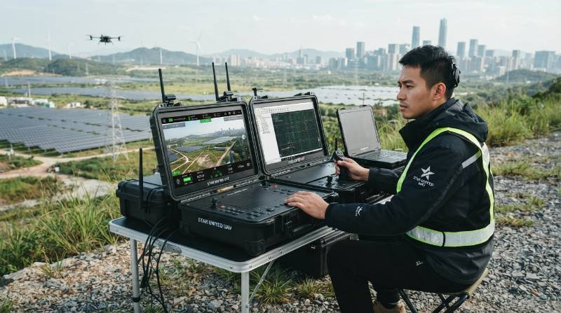
Enterprise GCS: A hardened hardware-software node executing real-time command, control, and communications (C2) protocols over localized or distributed data networks, translating georeferenced spatial vectors into deterministic motor, control surface, and sensor trigger commands.Consumer tablet applications rely on lightweight API polling that easily breaks under radio attenuation. Enterprise platforms leverage synchronous MAVLink telemetry or custom STANAG 4586 datalinks. These architectures maintain sub-50-millisecond latency across airframe command cycles, preventing packet loss during critical maneuvers. Hardware-software co-design remains the primary differentiator in mission planning execution. When software logic is detached from motor torque curves and sensor buses, planning algorithms produce routes that risk structural stalls in severe weather. Reliable platforms integrate direct bus communications to enforce aerodynamic safety limits automatically.
Core Automated Flight Architectures: Corridors, Grids, and 3D Complex Vector Tracking
Industrial linear infrastructures require flight planning engines engineered specifically for corridor and volumetric mapping. Automated corridor generation algorithms continuously calculate sensor ground sampling distance (GSD), camera overlap percentages, and bank angles along complex polyline paths like highways, pipelines, and rail systems. For large-scale spatial mapping, multi-rotor and VTOL fixed-wing UAV platforms utilize dynamic 3D polygon grids. These routines adjust forward lap and side lap calculations in real time relative to target elevation models, preventing image degradation and spatial gaps across rugged topography.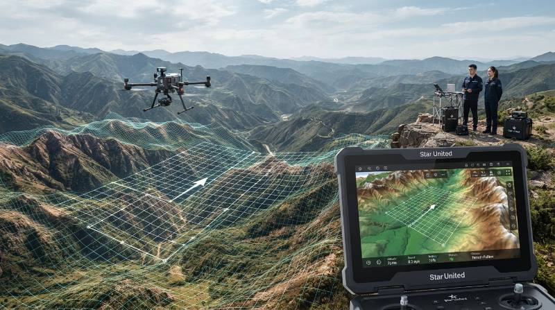
Dynamic Elevation and Vector Alignment
True 3D vector tracking bypasses traditional 2.5D raster elevation representations. Incorporating high-resolution digital surface models (DSM) directly into the mission planning engine maintains constant relative above-ground level (AGL) offsets, even over sheer vertical cliffs or alpine ridgelines.- Perpendicular Facet Tracking: Maintains camera optical axes normal to non-horizontal surfaces such as open-pit mining benches or dam walls.
- Curvilinear Smooth Interpolation: Replaces abrupt waypoint bank angles with continuous cubic-spline curves, conserving kinetic energy on fixed-wing airframes.
- Variable GSD Envelopes: Automatically modifies airframe velocity to match camera cycle times as local surface elevations shift.
The 4D Industrial Mission Survivability Matrix (4D-MSM)
Standard waypoint planners treat flight planning as a static, two-dimensional spatial problem. To guarantee mission execution in harsh industrial operating conditions, Star United UAV applies the 4D Industrial Mission Survivability Matrix (4D-MSM).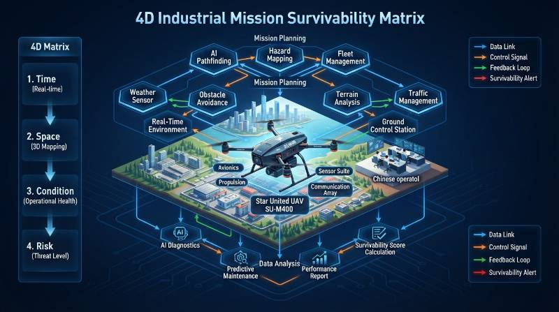
| Evaluation Dimension | Technical Architecture | Operational Impact |
|---|---|---|
| Dynamic Energy-Adaptive Replanning (DEAR) | Continuous tracking of battery internal resistance, motor thermal load, payload draw, and headwind vectors. | Dynamically shifts abort points to guarantee sufficient reserve capacity during sudden atmospheric wind shifts. |
| True 3D Micro-Terrain & Vector Tracking | Millimeter-level LiDAR/DEM terrain following for perpendicular facet inspection along industrial infrastructure. | Eliminates gimbal blind spots along 500kV vertical transmission towers and offshore turbine blades. |
| Sub-Millisecond Sensor-Airframe Sync Bus | Hardware-level clock synchronization across camera shutter triggers, IMU readings, RTK pulses, and telemetry. | Prevents photogrammetric lever-arm drift and eliminates LiDAR point-cloud divergence at flight speeds up to 18 m/s. |
| Degraded-Link & GNSS-Denied BVLOS Autonomy | Edge-native mission execution via deterministic onboard state machines, visual odometry, and inertial navigation. | Safely executes corridor runs and automated contingency landings through link loss and electromagnetic jamming. |
C2 Interoperability and Hardware Resilience: Handheld Units vs. Rugged Field Transit Consoles
The mission planning terminal serves as the tactical command center for field pilots. Consumer handheld tablets frequently fail under harsh environmental stress, suffering thermal throttling when ambient temperatures surpass 35°C or dropping display readability under direct sunlight. Industrial operations running enterprise heavy-lift rotary UAV platforms require dual-display transit cases certified to MIL-STD-810H and IP67 ingress protection standards. These systems preserve situational awareness by isolating primary flight instruments (PFD) from payload telemetry and mapping interfaces.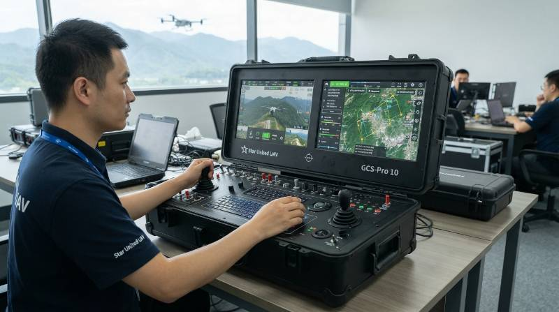
| Feature Parameter | Commercial Tablet Solution | Industrial Console (GCS-Pro 10) |
|---|---|---|
| Screen Luminance | 600–1,000 nits (throttles rapidly) | 2,500 nits (continuous, anti-reflective) |
| Operating Temperature | 0°C to +35°C | -25°C to +60°C (internally regulated) |
| Ingress Rating | IP52–IP54 (unsealed ports) | Full IP67 (milspec quick-connect ports) |
| Datalink Architecture | Single 2.4/5.8GHz consumer Wi-Fi/RF | Tri-band COFDM Mesh + LTE/SATCOM |
| Data Security | Consumer OS with cloud sync exposure | Air-gapped Linux, AES-256 encrypted C2 |
Extreme Mission Benchmark: Offshore Wind and 500kV Power Line Inspection Under Grade-8 Winds
Real-world industrial utility inspections expose mission planning systems to severe environmental limits. Consider high-consequence industrial inspection of offshore wind turbines and high-voltage transmission lines under Grade-8 wind conditions (up to 20.7 m/s) carrying a 15kg modular sensor payload. In high-wind operational corridors, basic mission software often triggers motor saturation or fails to account for aerodynamic crab angles. This misalignment ruins sensor ground coverage and drains battery capacity unexpectedly during downwind turns.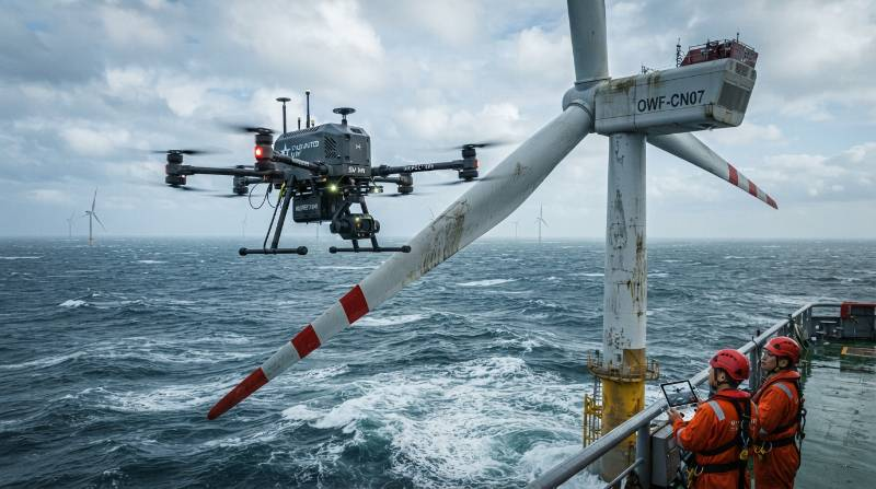
Star-Pathfinder™ Aerodynamic Compensation Engine
To operate reliably in turbulent corridors, Star United UAV systems embed the Star-Pathfinder™ Aerodynamic Compensation Engine directly into GCS routing logic. This subsystem processes real-time telemetry from onboard ultrasonic anemometers to stabilize mission execution:- Dynamic Heading Bias: Calculates instantaneous wind vector deltas, rotating the airframe heading to hold the payload stable while keeping motors inside safe torque bands.
- Fail-Safe Intelligent Energy Envelope: Recalculates remaining battery margins using dynamic continuous load formulas (Icont = 500 A peaks, Vin drop curves) rather than static battery voltage estimates.
- Adaptive Low-Drag Descent: Automatically plots safe downwind egress paths to secondary pre-cleared rally points if thermal limits are exceeded.
Safety, Airspace Compliance, and Enterprise Fleet Risk Management
Securing civil aviation approvals for Beyond Visual Line of Sight (BVLOS) operations demands mission planning architectures that integrate deeply into unified airspace networks. GCS systems must interface directly with civil aviation transponder feeds and remote UTM systems. Compliance begins with integrated Detect-and-Avoid (DAA) pipelines. By combining cooperative ADS-B In feeds with non-cooperative micro-radar and optical sensors, the GCS displays air traffic alerts directly within the primary navigation interface, plotting automated lateral deconfliction routes without operator lag.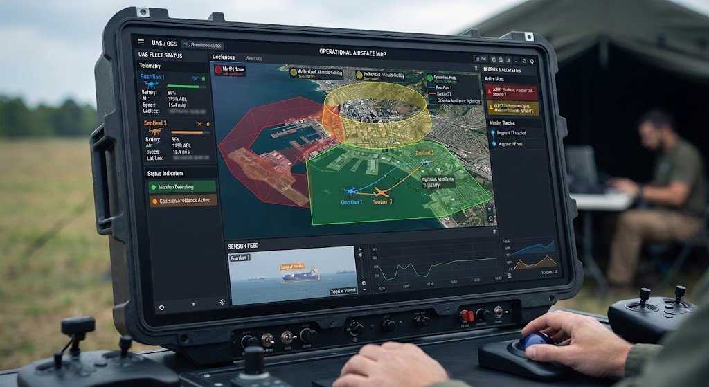
Multi-Stage Geofencing and Dynamic Abort Sequences
Static Return-to-Home (RTH) commands are unacceptable for enterprise infrastructure operations. Climbing to a pre-set altitude beneath high-voltage transmission lines or adjacent to structural wind tower blades can cause direct airframe collisions.- Spatial Geo-Fencing: Hard and soft geometric barriers rendered directly from localized spatial shapefiles prevent airframes from drifting into active transport corridors.
- Adaptive RTH Vectors: If the primary C2 link disconnects, the UAV retraces its clear ingress vector in reverse for 200 meters before evaluating climb corridors.
- Emergency Alternate Rally Points: GCS software maintains continuous situational awareness of pre-surveyed recovery zones, updating the nearest safe landing site as the drone traverses long linear utility corridors.
Procurement Matrix: Total Cost of Ownership, Licensing Models, and Fleet Orchestration
When evaluating UAV GCS platforms, procurement directors must examine total cost of ownership (TCO) over a multi-year equipment lifecycle. Inexpensive commercial software tools often rely on per-seat recurring subscription models that drive up lifetime operating costs. Enterprise platforms emphasize modular software SDKs, cross-fleet STANAG 4586 compliance, and hardware-integrated perpetual licensing. Selecting unified platforms simplifies technical training across large pilot crews and avoids single-vendor lock-in for critical fleet expansions.| Evaluation Vector | Open-Source / Off-the-Shelf | Proprietary Consumer SaaS | Industrial Integrated (Star United UAV) |
|---|---|---|---|
| Licensing Model | Open, unsupported | Recurring monthly/annual fee per seat | Perpetual enterprise license + SDK |
| Airframe Portability | MAVLink only | Restricted to vendor hardware | Universal MAVLink, STANAG 4586, Multi-Bus |
| 3D Micro-Terrain Engine | Basic 2.5D global elevation | Cloud-reliant DEM upload | Edge-native 3D volumetric facet tracking |
| EMI Resistance (Substations) | Low / Unshielded | Moderate | CE & FCC Class A Certified (up to 500kV) |
| Fleet Management & Swarms | External plugins needed | Cloud browser coordination | Native multi-node decentralized routing |
Frequently Asked Questions: Industrial GCS Architectures and Hardware Validation
What differentiates commercial tablets from integrated industrial GCS platforms?
Commercial setups using consumer iPads or Android tablets work well for basic open-field photogrammetry, but they throttle their screens under direct solar heat and lack the bus throughput required for dynamic 15kg dual LiDAR-thermal payloads in Grade-8 winds. Star United UAV co-designs ground control hardware directly with airframe avionics. This provides MIL-SPEC dual-radio direct bus communication, dynamic load-cell payload synchronization, -25°C to +60°C operating thermal thresholds, AES-256 air-gapped encryption, and reliable, zero-downtime performance in high-EMI power corridors.How can engineering teams validate genuine IP67 enclosure ratings and Grade-8 wind resistance?
Procurement teams should validate airframe and console durability by requesting three verified empirical certifications before purchasing:- Aerospace Wind Tunnel Test Reports: Demand certified aerodynamic test results showing active motor RPM balance and roll/pitch variance under turbulent flow up to 21.2 m/s.
- Third-Party Ingress Reports: Verify laboratory documentation confirming dust-tight enclosures and water immersion protection under high-pressure spray and temporary water submersion.
- Substation Electromagnetic Immunity: Validate uninterrupted operations using dual-RTK multi-constellation heading sensors with optical odometry within 5 meters of live 500kV transmission lines.
Why is STANAG 4586 interoperability important for non-defense commercial operations?
STANAG 4586 compliance establishes standard data interfaces between the GCS architecture and varied vehicle types. For enterprise fleet managers, this allows one unified console command interface to control diverse fixed-wing, heavy-lift rotary, and VTOL platforms without retraining field crews on separate mission software.Deploy High-Reliability Mission Control with Star United UAV
Star United UAV is an international manufacturer of high-reliability industrial drones, heavy-lift commercial UAV platforms, and mission-critical Ground Control Station (GCS) flight architectures. Designed for deep-corridor inspection, surveying, defense, and emergency response, Star United UAV systems integrate aerospace-grade hardware with intelligent, fail-safe autonomous mission planning software. Our manufacturing and flight integration lines comply with strict ISO 9001:2015 aerospace manufacturing standards. Systems feature verified Mean Time Between Failures (MTBF) exceeding 2,500 operational hours, backed by CE and FCC Class A industrial immunity certifications.Execute Your Mission Control Architecture Plan
Transition your enterprise fleet away from consumer tablet limitations toward deterministic, high-survivability mission control. Follow our streamlined three-step integration path:
- Operational Scope Submission: Submit your operating parameters—including target terrain, corridor length, wind and thermal profiles, and payload weights—through our secure engineering portal.
- Custom Architecture Blueprint: Within 24 hours, our avionics engineers deliver an end-to-end mission profile analysis featuring dynamic energy margins, GCS hardware configurations, and fail-safe flight paths.
- Flight Engineer Consultation & Live Demo: Join a technical deep dive with a Senior Flight Test Specialist, followed by a live virtual or on-site flight validation tailored to your application.