Heterogeneous UAS Control: UAV, UGV & Robot Dog GCS
Star United Flight Control (Shaanxi) Technology Co., Ltd.
7 min read·2026-09-21
Orchestrating Air, Ground, and Legged Robotics from One GCS
A unified ground control station coordinates multi-domain autonomous vehicles by standardizing telemetry, mission routing, and payload feeds across distinct kinematics into a consolidated command fabric. By bridging aerial autopilots and ground robotics middleware, a single operator can deploy fixed-wing or multirotor drones for wide-area reconnaissance while steering unmanned ground vehicles (UGVs) and quadruped robot dogs for close-quarters intervention. Managing disparate autonomous assets has historically required separate pilot consoles, multiple ground stations, and fragmented communications gear. This siloed approach increases operator cognitive load and introduces dangerous operational delays during fast-moving field scenarios.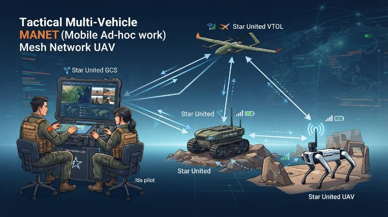
Multi-Domain Architectural Foundation: Protocol Translation and Middleware Bridges
The core challenge of heterogeneous robotics control lies in the protocol gap between aerospace avionics and ground robotics software stacks. Aerial platforms rely on lightweight serial message protocols, whereas terrestrial rovers and legged robots depend on node-based publish-subscribe architectures.Heterogeneous UAS Control: The simultaneous command, telemetry synchronization, and tactical data fusion of autonomous aerial, wheeled, tracked, and legged robotic assets through a shared communication backbone and unified operator interface.Aerial autopilots run primarily on flight control systems implementing the MAVLink protocol. Conversely, modern quadruped robots and industrial UGVs utilize the Robot Operating System (ROS 2) built atop the Data Distribution Service (DDS) standard for low-latency intra-robot messaging.
| Protocol / Standard | Primary Asset Domain | Throughput Profile | Typical Latency | Primary Role in Unified GCS |
|---|---|---|---|---|
| MAVLink v2 | UAV / Multirotor / VTOL | Low (10–50 kbps) | 10–30 ms | Avionics telemetry, GPS waypoints, battery stats |
| ROS 2 (DDS) | UGV / Quadruped Robot Dogs | High (1–20 Mbps) | 2–10 ms | Kinematics, joint state control, SLAM point clouds |
| STANAG 4609 | UAV & Ground Optical Payloads | Medium-High (2–8 Mbps) | 50–120 ms | Full-Motion Video (FMV) with synchronous KLV metadata |
| CoT (Cursor-on-Target) | Tactical C2 & ATAK Integration | Low (5–20 kbps) | 20–50 ms | Geospatial targets, situational awareness symbology |
Datalink Infrastructure and Dynamic MANET Mesh Sizing
Heterogeneous operations cannot depend on point-to-point analog links. Field teams utilize Mobile Ad-Hoc Networks (MANET) running COFDM (Coded Orthogonal Frequency Division Multiplexing) to establish dynamic, self-forming, and self-healing IP meshes.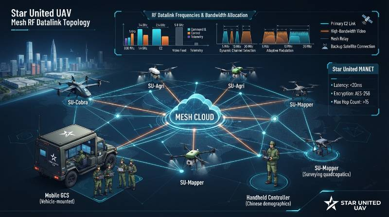
- Telemetry Data Stream: 15 to 45 kbps per agent (99.99% packet delivery target).
- Compressed Video (H.265): 1.5 to 4.0 Mbps per 1080p60 stream with dynamic bitrate throttling.
- LiDAR SLAM Dense Point Clouds: 2.0 to 6.5 Mbps (using spatial downsampling algorithms at the edge).
- C2 Safety Heartbeat: 10 Hz constant burst via dedicated frequency-hopping spread spectrum (FHSS).
The Star United Cross-Domain Orchestration Protocol (CDOP)
Managing multi-vehicle swarms requires a clear operational framework. Star United UAV engineers developed the Cross-Domain Orchestration Protocol (CDOP), a 4-phase deployment methodology designed for mixed-asset tactical teams.- Phase 1: High-Altitude Survey & RF Backbone Deployment: A long-endurance VTOL UAV establishes a geofence and deploys an airborne MANET mesh repeater at 400 feet AGL.
- Phase 2: Automated Cue-and-Handoff: Aerial thermal payloads identify target coordinates and autonomously broadcast Cursor-on-Target (CoT) waypoints directly to terrestrial units.
- Phase 3: Ground Ingress & Confined-Space Penetration: Wheeled UGVs advance across outdoor perimeters while quadruped robot dogs navigate stairwells, rubble, and narrow interior doors.
- Phase 4: Multi-Sensor Data Fusion: Spatial point clouds, optical feeds, and environmental telemetry from all active agents are fused into a real-time 3D common operational picture (COP) at the GCS.
Cross-Domain Operational Workflows in Critical Environments
Deploying mixed robotics platforms unlocks tactical configurations that isolated systems cannot match. In enterprise perimeter security patrol applications, real-time coordination transforms perimeter defense. When an aerial drone's thermal payload detects an unauthorized breach, the GCS automatically calculates the intercept vector. It routes a high-speed wheeled UGV to block the path while vectoring a quadruped robot dog to search blind spots beneath parked equipment. These coordinated air-to-ground tactics also transform long-range ISR surveillance missions. A rugged flatbed UGV acts as an autonomous forward refueling and landing pad (FARPO) for VTOL drones, extending aerial coverage indefinitely without requiring operator transit.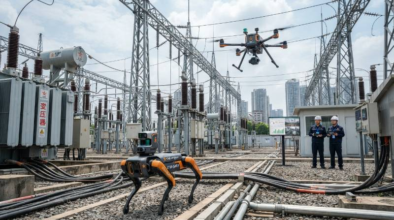
Unified Operator Interface: Split Dashboarding and Multi-Vehicle Payload Control
Single-operator multi-robot control requires an intuitive user experience. The Star United GCS software utilizes a dynamic split-pane interface that balances high-level mission oversight with manual payload intervention.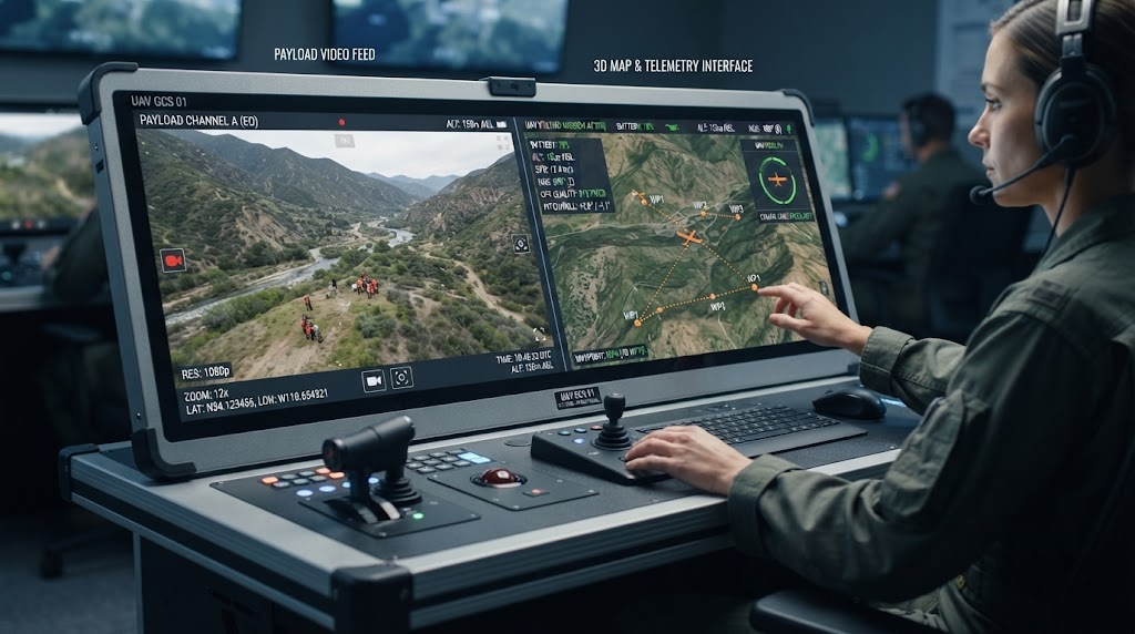
GNSS-Denied Navigation and Edge Compute Resilience
When operating in electronic warfare environments, deep tunnels, or heavy industrial processing facilities, satellite navigation signals are frequently jammed or completely unavailable. Heterogeneous UAS architectures address this vulnerability via collaborative localization. Using Visual-Inertial Odometry (VIO) and real-time 3D LiDAR SLAM, vehicles build and share spatial maps over the local mesh. According to international robotics guidelines such as ISO 21384 standards, autonomous systems must retain fail-safe station-keeping when external references fail. If a quadruped loses its local odometry lock inside a metallic bunker, it cross-references its position against the external geo-referenced SLAM anchor created by the overhead UAV before ingress. This decentralized edge localization ensures mission integrity without cloud or GNSS dependencies.Enterprise B2B Applications: Energy Substations, Mining, and Infrastructure Security
The operational return on investment for multi-domain autonomy is evident across demanding industrial sectors. In routine industrial inspection scenarios, multi-domain teaming delivers unmatched data quality and operational safety.- High-Voltage Power Substations: Aerial drones inspect overhead conductors and lightning arresters, while quadruped robots walk breaker lines to capture ground-level SF6 gas emissions and transformer acoustic anomalies.
- Open-Pit & Subterranean Mining: Aerial platforms calculate open-pit bench volumes via photogrammetry, while UGVs and robot dogs navigate active stopes and unventilated drifts to measure gas concentrations.
- Maritime Cargo Ports: Drones scan container stacks for thermal irregularities, and tracked ground rovers patrol container access lanes to verify automated terminal gate integrity.
Frequently Asked Questions (FAQ)
Can a single operator safely pilot an aerial drone and a quadruped robot simultaneously?
Yes, through supervised autonomy. The operator does not fly or step-control both assets simultaneously. Instead, platforms navigate autonomously along coordinated waypoints. The operator acts as a tactical supervisor, stepping in only to authorize actions or take manual payload control when needed.How does the GCS bridge MAVLink and ROS 2 without creating processing lag?
The system utilizes an embedded edge-level gateway using CycloneDDS and shared memory IPC. Telemetry fields are serialized and mapped in C++ binaries, achieving cross-protocol translation in under 5 milliseconds without bogging down the main processor.What happens if the RF mesh link is jammed or disconnected?
Assets follow automated lost-link fail-safes. Aerial platforms execute an automated climb, loiter, or Return-to-Home (RTH), while ground rovers and robot dogs safely pause, back-track along their inbound odometry path, or hold position with obstacle shields active until link restoration occurs.Can legacy or third-party rovers be integrated into a Star United GCS?
Yes. Any platform providing standard ROS/ROS 2 nodes, MAVLink communication, or RTSP/WebRTC video output can connect to the Star United cross-domain command suite via modular hardware integration bridge kits.Deploy Unified Multi-Domain Robotics Architecture
Empower your security, defense, or industrial inspection operations with our ruggedized, multi-vehicle Ground Control Stations and engineering integration services.
Request Technical Architecture Consultation